2013 (versión 1) - Mapa de Catastro Bananero de la provincia de Santo Domingo de los Tsáchilas, Escala 1:5.000, Año 2013
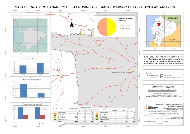
El catastro se realizó desde diciembre del 2012 a mayo del 2013 y consistió en el levantamiento de información de los predios bananeros mayores a una hectárea de monocultivo, que destinan su producción a la exportación.
|
|
(2013) . 2013 (versión 1) - Mapa de Catastro Bananero de la provincia de Santo Domingo de los Tsáchilas, Escala 1:5.000, Año 2013. http://geoportal.agricultura.gob.ec:8080/geonetwork/srv/api/records/65718b02-2a85-4920-84e2-d071ee2546a5 |
INSPIRE
Identificación
- Identificador del fichero
- 65718b02-2a85-4920-84e2-d071ee2546a5 XML
Recurso en línea
- resource_protocol
- WWW:LINK-1.0-http--link
- resource_protocol
- WWW:LINK-1.0-http--link
- resource_protocol
- WWW:DOWNLOAD-1.0-http--download
- resource_protocol
- WWW:DOWNLOAD-1.0-http--download
Identificador del recurso
- Idioma del metadato
- spa
- Tipo de representación espacial
- Vector
Codificacióin
- Formato
- shp
- Versión
- ArcGis
- Especificación
- shapefile
Proyección
- code
- EPSG:32717
- code
- WGS84 17S
Classification of data and services
- Categoría temática
-
- Agricultura
Classification of data and services
Coupled resource
Coupled resource
Classification of data and services
Coupled resource
Coupled resource
Palabras clave
Other keywords
- Palabras clave
-
- Catastro , Bananero , Banano , Escala 1:5000 , Santo Domingo de los Tsáchilas
- Palabras clave
-
- Ecuador
- Palabras clave
-
- 2013
Cobertura geográfica
N
S
E
W
))
Temporal reference
Extensión tempora
Extensión tempora
- Fecha ( Creación )
- 2013-07-30T00:00:00
- Fecha ( Publicación )
- 2013-11-26
Quality and validity
- Linaje
- La información levantada consistió en la medición perimetral del área de cultivo de banano y llenar la ficha de investigación catastral. Para la planificación del catastro se hicieron reuniones y/o se contactó con empresas de servicios agrícolas (aerofumigadoras) y asociaciones de productores para organizar la logística y coberturas de áreas bananeras.
- Denominador
- 5000
Conformidad
Conformidad
Conformidad
Conformidad
Conformidad
Conformidad
Restrictions on access and use
Restrictions on access and use
Responsible organization (s)
Contacto para el recurso
- Nombre de la organización
- MAGAP - CGSIN - DIGDM
- geoportal@mag.gob.ec
Responsible organization (s)
Contacto para el recurso
- Nombre de la organización
- MAGAP - CGSIN - DIGDM
- geoportal@mag.gob.ec
Metadata information
Contacto para el metadato
- Nombre de la organización
- MAGAP - CGSIN - DECDI
- geoportal@mag.gob.ec
- Fecha
- 2019-10-10T12:31:23
- Idioma del metadato
- spa
- Codificación
- UTF8